Wilgee Springs Project


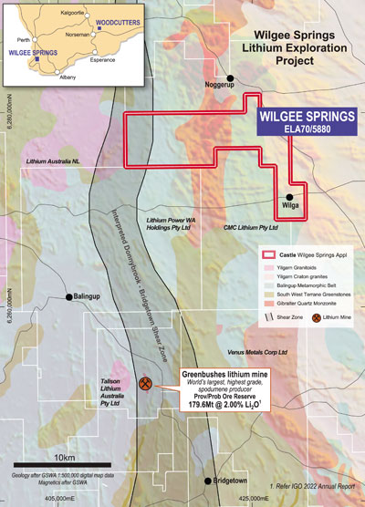
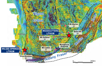
Castle Minerals Limited has applied for an exploration licence, Wilgee Springs (ELA 70/5880), encompassing 120km² along strike from and within the same metamorphic belt as the World-Class Greenbushes lithium mine, 25km to the south in Western Australia’s South-Western region.
The Greenbushes pegmatite deposit underpins the World’s largest, highest grade and lowest cost, hard rock, spodumene concentrate producing operation, supplying 21% of global lithium from a mineral resource of 178.5Mt at 2.0% Li₂O. The mine is owned by Albermarle Corporation / Tianqi Lithium / IGO joint venture. The pegmatites that host the spodumene mineralisation at Greenbushes are part of a late-stage intrusive sequence that was emplaced into the north-south trending Donnybrook-Bridgetown Shear Zone, a regional-scale lineament that can be traced for some 150km in the Archean Balingup Metamorphic Belt. This belt extends north of Greenbushes into the western portion of Castle’s application area.
In addition to the joint owners of the Greenbushes mine, Castle now joins Lithium Australia P/L, CMC Lithium P/L and Lithium Power Holdings P/L in the immediate area.
Extensive lateritic cover has obscured the geology and seriously hampered previous exploration. No records of exploration in the licence application area specifically for lithium or associated tin and tantalum have been located within the WAMEX open-file reports archive.
With the availability of today’s advanced geochemical and geophysical technology, this now presents an exciting opportunity for Castle to in effect “peer” below the cover and explore for lithium-bearing pegmatites.
The application area is situated over the Balingup Metamorphic Belt (BMB), which forms part of the Yilgarn Craton’s South West Terrain Greenstone. The BMB extends roughly north-south for over 200km and ranges in width from 50km in the south to 3km in the north. The rocks comprise highly deformed gneiss and granofels with minor quartzite, schist, BIF and ultramafic rocks. The BMB, which has been intruded by the Gibraltar Quartz Monzonite in the central part of the license area, is thought to be derived from partial melting of amphibolite bearing gneiss. Yilgarn Craton granites are located along the eastern margin of the application area.
